6/30/2006

Brins Fire...and its damage


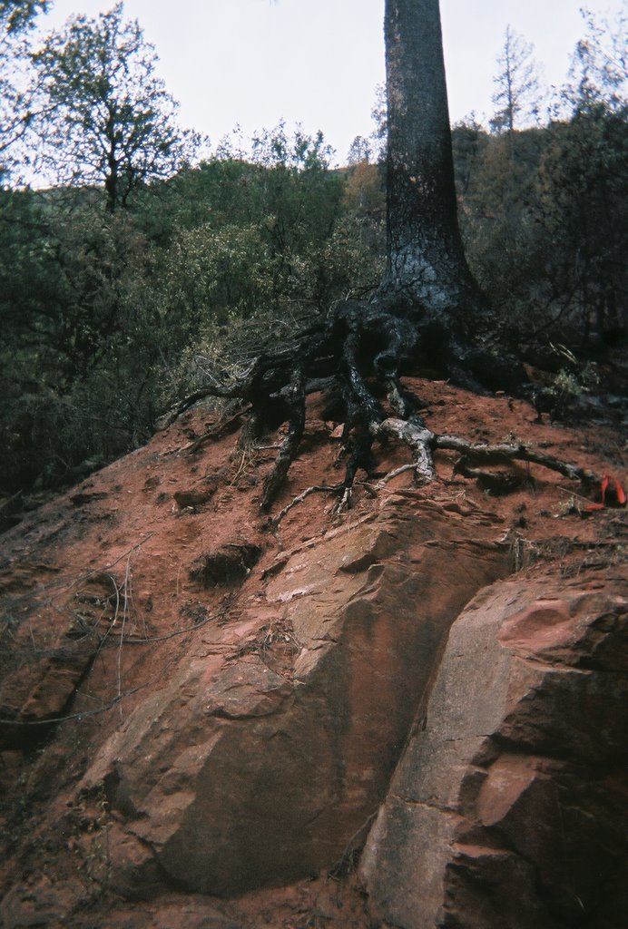
the fire completely exposed the roots
of this tree which sits right along 89A

click images to enlarge
charred landscape


Picture of a trailhead right across from one of the
campgrounds


It's been 2 weeks since the Brins fire started, and unbelievably, it is 100% contained, people are able to return to their homes and Hwy. 89A is reopened.

Until the rains come and produce enough precipitation, the forest will remain closed, the campgrounds will remain closed, and we will remain out of work. The vacation has been nice, but we can't go hiking, geocaching or 4 wheeling, so we've enjoyed lunch with friends that we work with. (fellow Alaskans), visited the casino once, drove 60 miles for lunch....and play backgammon!
Our employer did put us to work for a few hours when the Hwy. reopened. I helped Anne at Slide Rock Market...the power had been shut off for 3 days, so there was quite a sticky mess to clean up. We threw out over 400 ice cream bars and popsicles, dozens of hot dogs, and cleaned out all the coolers. They put Henry to work retrieving golf carts from the campgrounds and picking up the tents and supplies campers had to leave behind.

Our resume is back on the web, and we have offers for workamper jobs in MS, AR, CO, and CA. The one in California is very tempting and the closest....but will see.

6/15/2006

Smiley Rock


Lunch at the Haunted Hamburger in Jerome, before we began our jeep ride. Out of Jerome, through the Gold Mine and Ghost Town, up and around a mountain and finally down into Martin Canyon. A wild jeep ride through the canyon...so much that we originally missed 'Smiley Rock' on the way in. We were about 25 miles in when we decided we better turn around. The boulders on the 'trail' WERE the trail, and our jeep doesn't have the lift kit or taller tires yet.
At least in turning around and going back, we spotted Smiley Rock! Not wanting to return the way we came, we opted to follow the forest road shown on our map, which ended up taking us back to the mountain, which we didn't want to do as the time was getting late. The forest service map we just purchased is about 6 years old....so we put the map away and kept our eyes on the power lines to the left and the houses in the distance on our right. We opened an old cattle gate and continued .......finally reaching a paved road in a gated secured upper class neighborhood. The houses were huge with 5 car detached garages, horse stables on the back 5 acres....where in the world were we? After driving a couple miles through the community we reached the security gate and spotted the highway. So away we went, over the pass back through Jerome and home by 7:00 p.m. What fun!!

6/08/2006

Dad, what kind of cow is it???

On the road to East Pocket Lookout


Calf
A very ugly cow


Pronghorn Antelope


(click photos to enlarge)


Elk

Fire service roads in the high country


Views from East Pocket Lookout
(click photos to enlarge)


Yesterday we loaded up the jeep with water, lunch, our GPS units, and a plan. We headed up Oak Creek Canyon above the vista, and started west on fire road #535. We were only about 8 miles from the main highway, but the many 'spurs' we explored led us to an excellent lookout! The gate to the lookout tower was locked, possibly because of the fire restrictions, but we were still able to enjoy the views. And we saw more wildlife; deer, elk, lots of cattle, and even a pronghorn antelope!

6/01/2006

Hutch Mountain


click on photos to enlarge
There are at least 4 deer in this picture
blending in with their environment


They just stood and watched us

Lookout tower at Hutch Mountain


Temperatures have been in the high 90's here, so we headed for higher elevation and cooler temperatures. We took the jeep, topless and doorless, and drove about 50 miles northeast to Hutch Mountain. The Lookout Tower has a forest service worker that lives in the tower 6 days a week, so we spent time talking with him in his 'tower'. Great views in every direction from the tower.
The best part of today though, were the 20+ deer and 3 elk we saw. (No pictures of the elk I'm sorry to say). They were laying right next to the fire road we were on, our jeep startled them, and they were up and running right in front of us, but too quick for me to get the camera on.
On our way home we saw smoke in the distance, which appeared to be in the direction of Sedona. As we turned on Hwy. 179, there it was. A raging fire in Jack's Canyon which is a residential area in the Village of Oak Creek about 7 miles from Sedona. At least two houses have burned and the fire is not contained as of yet. Conditions here have been so incredibly dry, temperatures high, and fire restrictions were put in place over the Memorial Day weekend. Apparently, a homeowner was using a cutting torch, and a spark got away....sad. This is the first wildfire for the area and has so far burned 125 acres just since this afternoon.